20.11.05

Monumento Natural Tubo vulcânico de Todoque


Fotos: S. Reboleira

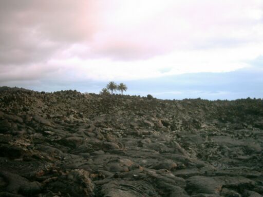
O Tubo vulcânico de Todoque (Ilha de La Palma, Canárias), está situado na escoada lávica de 1949, da erupçao histórica do vulcao de San Juan, município de Los Llanos.
Este tubo com uma extensao de cerca de 600m, é protegido desde 1987, vindo a ser posteriormente, reclassificado como monumento natural e área de sensibilidade ecológica.
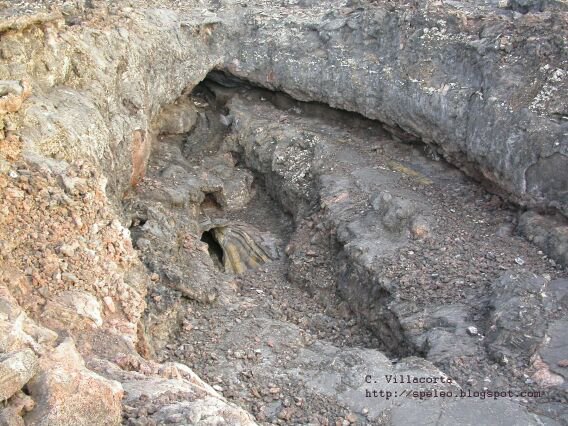
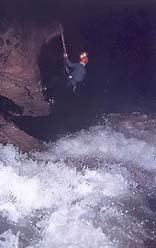
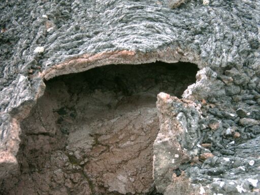
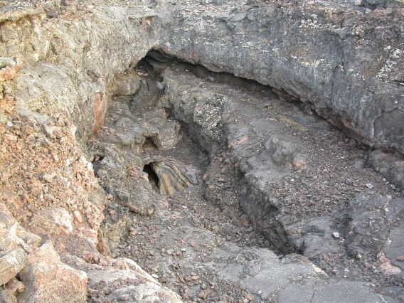
O tubo de Todoque tem inumeras aberturas naturais provenientes de abatimentos e de bolhas de gases, o que torna a progressao muito agradavel e supreendente.
Nao alberga uma grande diversidade de fauna hipogeia, mas conta com a presença de alguns endemismos rarissímos, como a Anataelia troglobia.
O solo é formado por lava tipo aa, e o tecto e paredes por estafilitos, é um tipico tubo vulcânico.
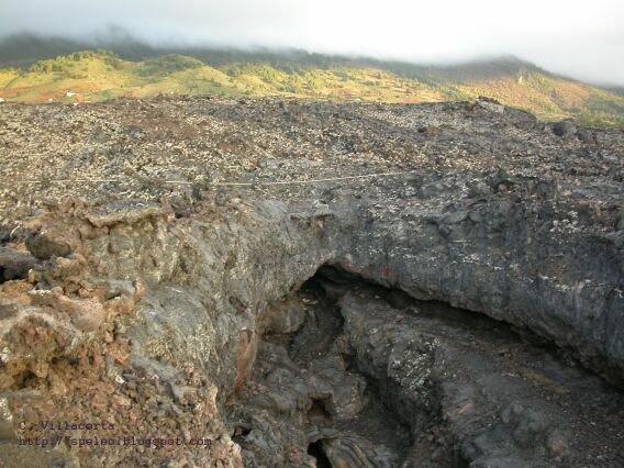
A saída do tubo permite uma vista fantástica pela escoada lávica, com o mar ao fundo e a floresta de laurissilva e pinhal de Pinus Canariensis acima.

RESERVAS DE LA BIOSFERA - UNESCO - Descripción: Gobierno de Canarias:

«...los tubos de lava son estructuras geomorfológicas propias de zonas volcánicas que en La Palma cuentan con una buena representación, siendo éste uno de los más largos de la isla. Su interés científico es eminentemente geológico y se acrecienta por su importancia biológica al albergar una fauna peculiar de formas invertebrados muy adaptadas a la vida hipogea.»

19.11.05

Simposio Internacional sobre el Uso Sostenible de las Aguas Subterráneas (ISGWAS)


Alicante (España), 24 - 27 DE Enero DE 2006

Site oficial: ISGWAS

Cave horror pupils 'swam for lives'

A classmate of a 14-year-old boy who died while caving has spoken of how they tried to escape after they found themselves trapped underground.
Amy Ryder, also 14, said Joseph Lister offered to let her go first when the tunnel they were caving in became submerged following flash floods.
Speaking to The Times, she said: "That was the kind of person Joe was. He was just being himself. Then he took a deep breath and went into the tunnel. That was the last time I saw him."
Joseph was part of a group from Tadcaster Grammar School who were learning the basic principles of caving in Upper Nidderdale, North Yorkshire, on the first day of an annual school trip on Monday.
His "lifeless" body was recovered from an area known as Manchester Hole following a search by a rescue team and he was taken to hospital with acute hypothermia. (...)

Riverbluff Cave Opens To Scientists, Public and Forecasts Future

One of the nation`s oldest caverns opens to the public Friday. The Springfield-Greene County Park Board will hold a dedication ceremony to unveil the new field house at the Riverbluff Cave.
The field house at Riverbluff Cave allows researchers to showcase their digs. It also has a laboratory area, office space, and classroom. It serves as an education center for people wanting to learn more about the Riverbluff Cave project. It also features online live-streaming of the 830-thousand-year-old cave."It`s a 23-hundred year old cave, and it`s packed with at least 20-feet of sediment," says Springfield-Greene County Naturalist Matt Forir. "It`s full of fossils, it`s full of trackings, it`s full of everything imaginable."Researchers have unearthed mammoth ribs, turtle shells, and horse bones since the caves accidental discovery September 11, 2001. Crews found the cave while blasting during road construction. Now the cave proves a treasure-trove for naturalists like Forir, who says perfectly-preserved insects from the Ice Age give researchers insight into Greene County`s past and future. (...)

Full text: Kolr.10

Boy dies alone trapped 1,000ft inside cave

Joseph Lister was last seen by his school friends as they stood inside a cave known as Manchester Hole.
The party of 11 pupils, a teacher and an instructor, had crawled through a stretch of the cave on their hands and knees until they reached a section big enough to stand in to admire the stalagmites. By now they were more than 1,100ft from the cave entrance. (...)
Full article: Telegraph.co.uk

Early Humans Settled India Before Europe, Study Suggests

Modern humans migrated out of Africa and into India much earlier than once believed, driving older hominids in present-day India to extinction and creating some of the earliest art and architecture, a new study suggests.
The research places modern humans in India tens of thousands of years before their arrival in Europe.
University of Cambridge researchers Michael Petraglia and Hannah James developed the new theory after analyzing decades' worth of existing fieldwork in India. They outline their research in the journal Current Anthropology.
"He's putting all the pieces together, which no one has done before," Sheela Athreya, an anthropologist at Texas A&M University, said of Petraglia.
Modern humans arrived in Europe around 40,000 years ago, leaving behind cave paintings, jewelry, and evidence that they drove the Neandertals to extinction. (...)

11.11.05

"La Grotta dei Cristalli"

Il progetto Naica
"La Grotta dei Cristalli", Naica, Chihuahua, Mexico


"Naica è un tipico paese minerario ubicato nel nord del Messico (latitudine 27°52'00"N - longitudine 105°26'15"W - quota 1500 m s.l.m.), nello stato di Chihuahua, 130 km a sud est della capitale omonima e circa 35 km da Ciudad de Delicias, nel municipio di Saucillo.Secondo la tradizione, Naica significa "luogo senza acqua" ma, molto più probabilmente, tale termine è di origine Tarahumara, proviene dalle radici Rarámuri "Nai" (luogo) e "ka" (ombra), e significa "luogo ombreggiato", come giustificherebbe l'ombra proiettata dalla sierra isolata nel deserto circostante.(...)"

10.11.05

Crawling through Hawaii lava caves opens undiscovered world

"About the time jagged edges started poking through my T-shirt as I wormed my way through a tight spot in a lava tube, I began to wonder: What am I doing here?
We could have been relaxing on the famous Green Sand Beach at South Point of the Big Island of Hawaii. But in the spirit of adventure, we were instead exploring the world underground.
I had convinced my husband that it would be neat to go hiking to see flowing lava at the Kilauea Volcano on the first night of our weekend getaway, and then get up early the next morning to go caving in 1,000-year-old lava tubes. (...)"
Full Text: USATODAY

Japanese soldier skeletons found

"THOUSANDS of skeletons of Japanese soldiers killed during World War II have been found on an island in Indonesia's easternmost province of Papua.State-run news agency Antara said the remains were found by Japanese researchers, along with Indonesian security forces and local residents.
Antara said the skeletons were found recently inside a cave on Wakde Island on the eastern part of the province.
Chief Sergeant Hans Kadiwaru, a local soldier involved in the research, said the researchers began the work in September.
Along with the skeletons, the researchers discovered weapons, military helmets, telescopes and other equipment.
"Most of the skeletons belonged to Japanese soldiers and some to local villagers, who are believed to (have) hid from Allied forces' attacks," Kadiwaru said.
The skeletons were flown to Japan, he said.
The researchers also found an airport, believed to be built by the Japanese soldiers, on the island.
The airport was covered with trees and wild plants when it was found."
Text from: The advertiser

Japanese researchers find Buddhist stone caves in Afghanistan

A team of Japanese researchers has found Buddhist stone caves believed to date back to the eighth century about 120 kilometers west of the Bamiyan ruins in central Afghanistan, the team said Wednesday.
The team, headed by Ryukoku University professor Takashi Irisawa, confirmed in late October the discovery of a group of caves built on cliffs located 1 km west of the Keligan ruins in the upper Band-e-Amir River area.

The discovery indicates the possibility that the influence of Buddhism may have extended to the area of the upper waters of the river centering around the Keligan ruins around the eighth century, and that the religion's sphere of influence in the region may have been greater than previously thought, team members said. Islam was beginning to gather momentum around that time.

"It will provide an invaluable clue in researching the sphere of Buddhism stretching westward," said Irisawa, an expert on Buddhist culture at the Kyoto-based university.
(...)

Full text: http://www.kashar.net/complete.asp?id=2548

9.11.05

Mysterious Hawaiian Tiki Stir Debate

"More than 20 rare, carved wooden figures dating to the early 19th century recently were discovered in a cave at North Kona, Hawaii, according to several newspaper reports from the Big Island.
The objects are believed to be tiki, which native Hawaiians refer to as "ki'i," or carved images of gods thought to house spirits.
Construction crew workers accidentally breached the lava tube cave while preparing for a 450-acre residential and golf development at Kohanaiki. News reports said state officials were brought in to further investigate the cave, which now is sealed and under 24-hour security watch.
Lava tube caves are caves that form from fluid lava that has hardened. Similar to limestone caves, some lava tube caves in Hawaii go 50 feet into the ground.
The California firm of Kennedy-Wilson International owns the property, which is being developed by Rutter Development Corporation. (...)"

Full article: Click here

8.11.05

"Cada um no seu campo, pelo seu trabalho, contribui para se atingir um todo imprevisível.

Esta é a bela e misteriosa aventura da investigação científica.

As descobertas não têm interesse senão pelos problemas que desencadeiam."

Michel Bouillon
in 'A Descoberta do Mundo Subterrâneo'

4.11.05

Medidores laser

Stanley TLM Laser Measurers

WWW.SPELEOGENESIS.INFO - BULLETIN n.9, October 1, 2005

NOW ONLINE - VOLUME 3, ISSUE 1, 2005
This Bulletin announces the release of the next issue of the "Speleogenesis and Evolution of Karst Aquifers" Journal – Volume 3, Issue 1. It contains five articles, four being re-published from other sources and one original contribution. It also contains three book reviews. The content follows at the bottom of this Bulletin.
The content of the current issue appears on the main page of the site, from where one can jump to HTML or PDF (screen) versions of papers, or download ZIP containing PDF-printable versions (recommended to those who prefer to print a hard copy for personal use). You can download selected papers, or the whole issue by just one click.Papers published in the previous issues of the Journal are available via the “Jump to:” line or in the Journal Archive section (http://www.speleogenesis.info/archive).
NEXT ISSUE IN PREPARATION – Volume 3, Issue 2, 2005

Speleologists Safe Home After World's Deepest Cave Adventure

"The four Bulgarian speleologists that were trapped in the world's deepest cave Krubera returned safe to Bulgaria.Teodor Kisimov, Konstantin Stoilov, Svetlomir Stanchev and Orlin Kolov were part of the joint Bulgarian-Ukrainian expedition that explored Krubera.They were trapped in the cave for a few days due to torrential rains that resulted in increased water level in the cave.Teodor Kisimov, Konstantin Stoilov and Svetlomir Stanchev reached a depth of 2,080 meters earlier, going in deeper than any Bulgarian has ever been."
Text from: novinite.com

3.11.05

Gypsum karst and its evolution east of Hafik (Sivas, Turkey)

By: Uğur Doğan, and Sadettin Özel
"Sivas and its surroundings is the most important gypsum karst terrain in Turkey with a massive Lower Miocene gypsum formation 750 m thick. The region east of Hafik has a wide variety of well developed karstic features such as karrens, dissolution dolines, collapse dolines, blind valleys, karstic springs, swallow holes, caves, unroofed caves, natural bridges, gorges and poljes. The karstification started in the Early Pliocene. The piezometric level to the east of Hafik has lowered at least 200 m since the Early Pliocene and 90–100 m since the Early Pleistocene. There is a youthful karst (doline karst) on the Higher Plateau (1520–1600 m) and a mature karst on Lower Plateau (1315–1420 m). The mature karst evolved in two stages, first stage where excessively karstic paleovalleys, uvalas and collapse dolines appear and the second stage where poljes, collapse dolines and degraded collapse dolines dominated. "
Geomorphology Volume 71, Issues 3-4 , 1 November 2005, Pages 373-388
Abstract on ScienceDirect: Click here
Karst region around Sivas, Hafik and Zara
"Tertiary Era limestone extends underground between Sivas in the west and the regional center of Imranli in the east and a karst landscape dominates the upper Kizilirmak for a distance of 100km/62mi, extending 10-20km/6-12mi on both sides. The river has cut its way through the layers of gypsum to create this wide valley and for over 100km/62mi it flows mainly through red sandstone, gypsum and marl. There are many tributaries which give the water a permanently dull red color, hence the name Kizilirmak ("red river"). The high levels of sodium and potassium compounds also give the water a bitter taste. The higher gypsum plateaux at about 1,550-1,650m/5,000-5,500ft are riddled with a dense network of dolines. The slopes close to the river abound with 50-100m/165ft-325ft wide and 30m/100ft deep funnels and craters with swallow holes (ponors). Uvalas and tiny poljes with shallow lakes and marshes have been created from larger dolines merging together." Text from: PlanetWare

Autumn swarming behaviour of Natterer’s bats in the UK

Autumn swarming behaviour of Natterer’s bats in the UK: Population size, catchment area and dispersal

by: N.M. Rivers, R.K. Butlin & J.D. Altringham

"Many species of temperate bats visit underground sites in autumn, prior to hibernation, and chase each other in and around the entrances in an event known as autumn swarming. It has been suggested that swarming is a mating event that facilitates gene flow between bats from otherwise isolated summer colonies. We describe swarming behaviour at a cluster of four caves in the North of England and provide direct evidence for seasonal migration of Natterer’s bats (Myotis nattereri ) between these caves and many summer nursery roosts in a catchment area of at least 60 km radius. Mark-recapture analysis suggests that an estimated 2000–6000 Natterer’s bats use the three best-studied caves, together with smaller numbers of four other species: M. daubentonii, M. brandtii, M. mystacinus and Plecotus auritus. Recaptures also show that there is a small interchange of bats between these three caves, which are 0.6–1.5 km apart. Capture rates, automatic logging and video recordings at one cave suggest that an average 310–400 bats visit the cave each night. Mating at swarming sites would be particularly important for gene flow if a species showed no other dispersal pattern. We provide evidence for natal philopatry, with little or no dispersal, in both sexes of Natterer’s bats. The protection of swarming sites is discussed in light of our findings. "
Biological Conservation Volume 127, Issue 2 , January 2006, Pages 215-226
Abstract on ScienceDirect: Click here

Arctic Siberia: refuge of the Mammoth fauna in the Holocene

By: Gennady G. Boeskorov
"Global climate change at the end of Pleistocene led to extinction in the huge territories of Northern Eurasia of the typical representatives of the Mammoth fauna: mammoth, woolly rhinoceros, wild horse, bison, musk-ox, and cave lion. Undoubtedly the Mammoth fauna underwent pressure from Upper Paleolithic humans, whose hunting activity could also have played a role in decreasing the number of mammoths and other representatives of megafauna. Formerly it was supposed that the megafauna of the “Mammoth complex” had become extinct by the beginning of the Holocene. Nevertheless the latest data indicate that extinction of the Mammoth fauna was significantly delayed in the north of Eastern Siberia. In the 1990s some radiocarbon dates established that mammoths existed in the Holocene on Wrangel Island—from 7700 until 3700 yBP. Radiocarbon data show that wild horses inhabited the north of Eastern Siberia 4600–2000 yBP. Muskoxen lived here about 3000 yBP. Some bison remains from Eastern Siberia belong to the Holocene. The following circumstances could promote the survival of representatives of Mammoth fauna. Cool and dry climate in this region promotes the maintenance of steppe associations—the habitats of those mammals. Late Paleolithic and Mesolithic settlements are not found in the Arctic zone of Eastern Siberia from Taimyr Peninsula to the lower Yana River; they are very rare in basins of the Indigirka and Kolyma Rivers. The small number of Stone Age hunting tribes in the northern part of Eastern Siberia was probably another factor that contributed to the survival of some Mammoth fauna representatives. "
Quaternary International Volumes 142-143 , January 2006, Pages 119-123
Third International Mammoth Conference, Dawson, Yukon
Abstract avaible in ScienceDirect: Click here

1.11.05

Cave diving trip turns into hurricane survival ordeal for group from Cape Coral

The trip to Cancun, Mexico, was to explore the wonders of underwater caves in the Caribbean.
The trip turned into a fight for survival as six people from the Scuba Dragons Dive Team in Cape Coral were face to face with Hurricane Wilma.
How horrifying was this adventure? Consider this:

• With Wilma closing in, the six were escorted from their hotel at gunpoint and sent to a supposedly more secure location.• The roof was blown off, walls crumbled and water poured into one of the shelters where they endured most of the 36 hours of Wilma.

• Along the way they made several critical decisions that probably saved their lives.
Full article: News-Press

Lapiás China


...do blog Klepsydra (Floresta de Pedra, Yunan, China, Janeiro de 2005)

"O primeiro caracter significa floresta. Este caracter é composto por dois caracteres que individualmente representados significam árvore, como quem diz: duas árvores fazem uma floresta. O segundo caracter significa pedra. Floresta de Pedra. Foi esculpida pelas correntes marítimas do fundo do oceano numa outra era do nosso planeta. Esta Floresta de Pedra encontra-se a cerca de 2000 metros de altitude..." Texto: Klepsydra

1er Congrés Valencià d'espeleologia

SISTEMA CHEVE

EL SISTEMA CHEVE, UNO DE LOS SISTEMAS SUBTERRANEOS MAS GRANDES DEL MUNDO. MEXICO.


"La colosal cavidad conocida como Sistema Cheve, se encuentra situada en la Sierra Juárez, en el estado de Oaxaca, México. Cuenta con 26 kms de longitud y un desnivel de 1.475 metros. Actualmente el Sistema Cheve ocupa el primer lugar entre los sistemas de cavernas más profundas del país, y el noveno en el mundo.
En 1986 dos espeleólogos de Estados Unidos descubrieron la entrada principal a la cueva Cheve, en una gran colina de 2.720 metros de altitud sobre el nivel del mar, al noroeste del estado de Oaxaca. Este sistema montañoso tiene el potencial de alcanzar una profundidad de -2.300 metros.
Expertos de todo el mundo colaboraron en las exploraciones del Sistema Subterráneo. Entre 1.986 y 1.990 las galerías de la cueva resultaron de difícil factura debido a los numerosos pozos que hay que descender, su longitud y frialdad. (...)" (REDACCION FOTOS: MATT OLIPHANT, KASIA BIERNACKA Y MARCIN GALA)
Full article: CotaCero